 |
| It has been said that getting lost will help you find yourself... Photo GMARA.. |
My husband Dave has been the best supporter of my adventure racing lifestyle over the last several years. Kid duty, photographer, race crew, tolerator of all things... just to name a few. I have tried many times to convince him to join me, but it wasn't until this year that he finally conceded. And just like that, team Scrambled Legs & Aching was formed for the 12-hour GMARA Bitter Pill Adventure Race held at Bolton Valley, VT.
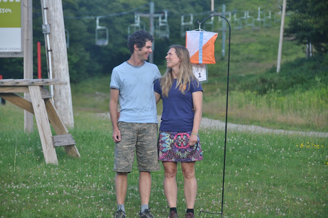 |
| Looking a little terrified during our pre-race official photo. At least we are in it together. Photo GMARA |
Both Dave and I have a fair amount of experience in the disciplines of sport that would be included in the Bitter Pill. We are both experienced paddlers, are avid hikers, and ride mountain bikes all summer (admittedly, Dave much more enthusiastically so than I). We were both also well-prepared for some swimming or a ropes component, but those would not end up being part of this year's event. Orienteering, on the other hand, is an area where we are both inexperienced. I mean, I have watched other people navigate using a map and compass for whatever that is worth. Successfully navigating to the required checkpoints using a map and compass while biking, hiking, canoeing, etc. could prove to be an incredibly interesting challenge. There would be a good chance that much of our day could be spent lost in the woods. So, at 4 AM, we showed up at the pre-race meeting with our gear packed and compasses slung around our necks ready to learn what our fate would be.
The race began with a 35-minute bus ride in the darkness to the start location. At 5AM, we were led to a field of canoes and kayaks (with no water source apparent anywhere), handed our maps (made from data 30 years old), and instructed that all racers who arrived at the finish after 5PM would face a checkpoint penalty in accordance with how many minutes late they arrive. There was a loud and clear message in that directive: DON'T BE LATE! I wondered if we should just start looking for the finish now...
 |
A cool photo of team Strong Machine snagging a
checkpoint on the paddle. photo GMARA |
With first light illuminating the sky, we portaged our canoe overhead toward the first checkpoint about 1km away. We scrambled through long grass, over a barbed-wire fence, and finally roadside toward the muddy put-in on the Winooski river, which was running unseasonably low due to the dry summer conditions. The paddle to the first few checkpoints began in a pretty uneventful manner, and Dave and I settled in and started thinking that perhaps it was going to be a good day. The reality is, that things are never quite that simple. Not two seconds after Dave commented how his paddle was feeling unusually flexible in the water I heard the unmistakable crack of plastic snapping followed by several expletives from Dave. Gleaning over my shoulder, I could see there was clearly a problem; Dave only had 1/3 of a paddle blade attached to a cracked shaft. In all fairness, the paddle now made an excellent pole to push the canoe over the shallower sections of river. With a cracked shaft already, this didn't seem like the smart thing to do, however. So we paddled on, with the blade of Dave's paddle sounding like it had a sneaker attached to the end each time it punched into the water. Kerplunk, kerplunk, klerplunk. As the early morning fog hung low over the the river, the stillness only broken by the riffles of the current, we forged on, a little embarrassed that we were the only team of over 50 that managed a broken paddle in the first kilometer of the race. Kerplunk, kerplunk, kerplunk...
 |
| Paddling down the Winooski. It appears that we still have two complete paddles at this point in time. That portage totally destroyed my braid, but the way. Photo GMARA |
By the time we reached the next portage around a large dam at checkpoint #3, the race directors had caught wind of the rumor that a couple of suckers were paddling a canoe with only half of a paddle and a new paddle was ready and waiting. I began to wonder if we told them that we were missing a qualified navigator, they would have provided us with one of those too? I forgot to mention (yeah, forgot, let's go with that), that we missed the third checkpoint during this portage and had to run back to punch our passports.
 |
| Here is a funny picture of me trying to make sure that Dave stays up on his nutrition by forcing him to take his Endurolytes and Endurance Aminos. Eat it!! Photo GMARA. |
The next several checkpoints were easily found along small tributaries, islands, or footbridges along the Winooski River. I was really grateful that they were all pretty easily navigated to, because paddling upriver for a missed checkpoint would be a real bugger. It was actually a beautiful and enjoyable paddle, and we arrived at the first transition area feeling great and in high spirits.
 |
| Punching CP #6 on the footbridge of the Long Trail. Ironically, Dave and I spent hours lost on the Long Trail with the kids near Smuggler's Notch this winter. We have since re-named it the Wrong Trail. Photo GMARA |
 |
| TA 1 waiting for racers to arrive. Photo GMARA |
The next leg was a mountain biking leg consisting of a small amount of paved road, to gravel road, to trail. We started out with a navigational mishap early on in the leg (oops, missed a turn), but found the checkpoints without too much trouble after that. This leg was around 27km in total- my estimation is that at least 24km of the leg was climbing (and lots of hike-a-bike). You might think this is impossible... that exaggeration is in my genetics.... I'll deny it. It IS entirely possible. Having just converted my mountain bike drivetrain to a 1X, I was definitely missing the existence of true grandma gear for the steeps. Let me tell you, that downhill was pretty exciting though (I might have yelled yee-haw once or twice, but I'll deny that too).
 |
| Headed out of TA 1 on the beginning of the bike leg. Photo GMARA |
 |
| Dave on his way out of TA 1 Photo GMARA |
We rolled into the second transition area (best guess at 11:30 am), dropped some gear and took a few minutes to plan our navigation for the next leg of the course. While the paddling and biking legs required checkpoints to be collected in order, this section was an orienteering section where eight checkpoints could be collected in any order. We made a plan to punch checkpoint (CP) #13 first and them make our way up the mountain to collect the checkpoints along a ridgeline and summit route afterward. We departed with Kate, Cliff, and Grey of team Strong Machine who were headed to the same checkpoint in search of a tributary intersecting with the drainage of Joiner Brook. We chatted along and probably were a bit distracted just long enough to
 |
Headed out to CP #13 from the transition area with team Strong Machine.
Photo GMARA |
misinterpret the scale of the map (which was made using 30-year old data), putting us further upstream than any of us realized. After about 30 or 40 minutes of scouring several drainages (both dry and with flowing water), we all agreed that we were not near the checkpoint. Dave and I returned to the transition area and re-thought our scale, and resumed searching for drainages that appeared to match the drainage shown on the map further downstream (here is where I remember specifically being told not to rely on river drainages for navigation by one of the race directors the night before). Having lost nearly an hour, we decided on a different approach. We decided that we would not look for the drainage from the brook, rather we would take a bearing from a snowmobile bridge that seemed to appear on the map. We followed the bearing, only to wind up in the exact spot where we had been 20 minutes earlier. Still, no sign of the orienteering flag.
 |
| Here is a Google Map of CP #13. The CP was shown on our map (looked like this one, but much smaller scale) to be a little ways up the drainage shown as the southernmost E-W drainage intersecting with Joiner Stream. This is also likely based on 30 -year old data. |
 |
Here is a current GoogleEarth image- same scale. The drainage doesn't appear to be here at all any more. Furthermore, the character of the river is also entirely different from the GoogleMap above. I blame hurricane Irene for this chaos. That is my story and I am gonna stick with it.
Here is one reason to always question streams shown on 30 year old data. |
Here is what I have learned that has been confirmed by other adventure racers since then: some check points just aren't meant to be found. At least, not by us. At least not on this day. Our difficulty on this day was that we weren't willing to admit that. Two hours later, we returned to the transition area once again, empty handed, baffled.
We now had around 3 hours remaining to search for checkpoints on foot before getting back on our mountain bikes for the final leg of the race. All of the checkpoints in this section were complete bushwacks- no trails, no significant drainages, and in most places the foliage was so thick it was difficult to see benchmarks like mountain tops or ridges. We decided to reverse our plan and approach the checkpoints in the opposite order, beginning with CP #14 and climbing the mountain from the other side, gathering as many as checkpoints as possible in the allotted time. The climb was steep, the vegetation thick (thanks for the souvenir, poison ivy), and the navigation was challenging, but we collected 4 more checkpoints in the next two hours. After a particularly thick section of bushwhacking reminiscent of our search for lost AT thru-hiker, Gerry Largay, in 2013, we approached checkpoint #18 around 3:15pm. After a pretty hasty search, we made the difficult decision to abandon the search for the checkpoint to return to the transition area, hoping to gather CP #19 on the way down the mountain. There would be no sense snagging checkpoints only to lose them in a penalty for arriving to late to the finish line. Unfortunately, as luck would have it, neither of those checkpoints would be punched on our passport either.
 |
| Nothing like rolling up to a finish line in grandma gear on the bike. I suppose that is better than pushing it though, right? Helmet with a hat? Really it IS a thing. Photo credit: GMARA |
We made it to the transition area and hopped back on our bikes to ride up to the finish, collecting the final two CP's on the way up. It turns out that a volunteer at the transition area had given Dave a map that would show the current location of nordic trails that we needed for the remainder of the course. That map somehow never made it out of the transition area with us. Oops- rookie mistake #5 (or is that #6- but who is counting?). Luckily, the larger, older map would suffice since the journey was not too tricky (just peddle UP). All in all, we could collect 17 of the possible 21 checkpoints along the way and finish with 15 minutes to spare.
Maybe there was, after all, time to go back for CP #13? Not a chance.
 |
| Team Scrambled Legs and Aching at the finish after a great day of racing. Photo GMARA. |
Thanks to the ladies at
Spandits! (check out their awesome new prints! If you use code SPANDITSLOVE and tell them I sent you you'll receive 10% off your entire order). Also a shout out to the great folks at Hammer Nutrition (use this link to
Hammer Nutrition for 15% off your first order) for fueling us through another great adventure. We felt great all day thanks to Hammer's awesome fuels (Heed, Sustained Energy, Endurolytes and Endurance Amino).
Finally, thanks to Shawn, Chris and the volunteers at
GMARA for putting on an amazing event and generously letting me share their photos!


